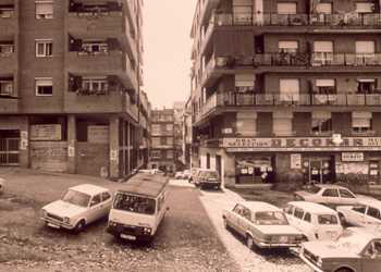
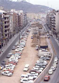
Previous state
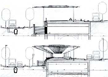
The first residents of the Verdum and La Prosperitat districts arrived in 1917 and built their own dwellings, consisting of shacks, in the middle of vines and fields. In 1929 the Municipal Council decided to plot the route of the Via Júlia (40 metres wide) thus anticipating the future needs of communication which were not observed by the urban planners. Even so, a number of existing buildings constricted the new route. The growth of these new districts stopped during the forties, but the lack of infrastructures, facilities and, above all, communications (the first bus did not come to the district until 1953) clearly highlighted unsustainable shortcomings. In 1952 a housing project known as the "Cases del Governador" (Governor's Houses) was built in the Verdum district (906 dwellings with an average floor space of 22 m2) and in 1954 the "Obra Sindical del Hogar" (Union Housing Organisation) promoted the construction of almost 1,500 low-quality dwellings. It was also from this time that a number of proposals for development (a specific proposal for the Via Júlia in 1960 was not carried out) failed to structure the existing planning chaos. Until the Via Júlia was given a coherent layout, it consisted of two rectilinear stretches linked by a gently curving section of differing widths.The tunnel for the Roquetes metro station occupied a site 120 metres in length, two metres above the southern side of the roadway. The lack of connection with the cross-streets (which are steeply sloping) was an added problem. The western end of the roadway ended at a circular square which distributed the traffic flow, and at the far south there was a strip of land, over 500 m. long, which was practically abandoned and had become a steeply sloping marshy area and a place for the random parking of cars.
Aim of the intervention
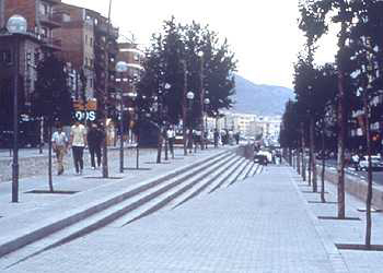
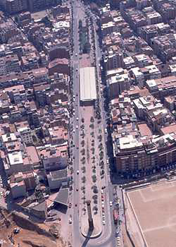
In order to proceed with the complete development of the road, we needed to address a number of existing problems: how to join the two stretches of road (at a slope of up to 2.5m), how to deal with traffic movement and the integration of infrastructures (sewers and service pipes). From a planning point of view, the intervention needed to connect the districts of Verdum and La Prosperitat as part of a series of smaller interventions which formed a new network of pedestrian walkways based on green areas and meeting points: the Plaça d'Àngel Pestanya, the pedestrianised Carrer de Conflent, the Plaça de Francesc Layret and, on the other side, the Plaça d'Otero Pedrayo, the Plaça Llucmajor and the Parc de la Guineueta. It was therefore necessary to define the new Via Júlia as a restructuring space -which could be used by pedestrians-, as a meeting point and metro access.Description
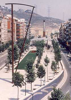
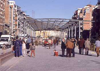
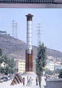
The first section, from the Plaça Llucmajor to the inflection at the Plaça Francesc Layret, is dominated by avenues at the side with 8-metre-wide pavements and double rows of trees. On the second section, between Layret and Via Favència, the two roadways are further apart, separated by an avenue whose central section is 23 m. wide. The first subsection of this space contains Sergi Aguilar's sculpture entitled "Júlia" dedicated "to the new Catalans" as a clear tribute to the incomers from the rest of Spain who set up their homes in the Nou Barris district. The cast-steel structure is 18 m. high and weighs about 18 tons. The second subsection is covered with a large metal canopy, and includes a children’s play area and, on a lower level, the access to the metro station. Finally, the third subsection is laid out in a semi-circle with walls running concentrically, and is dominated by a column light by Antoni Rosselló, measuring 24 m. in height and known as the "Torre Favència".Assessment
There is no doubt that the Via Júlia development has fulfilled the aims expressed earlier. In spite of the existing problems mentioned above, this thoroughfare has been transformed from an impassable barrier to a civic thoroughfare for socialisation -which has also been revitalised by commerce -and at the same time has unified the programme of open-spaces which has been carried out in the district. The participation of the inhabitants has been a decisive factor in defining the project. The central avenue was just one of the suggestions made, and the idea was adopted by the municipal architects following discussions with the neighbours' assocations.Albert García Espuche, architect
[Last update: 02/05/2018]