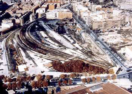
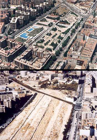
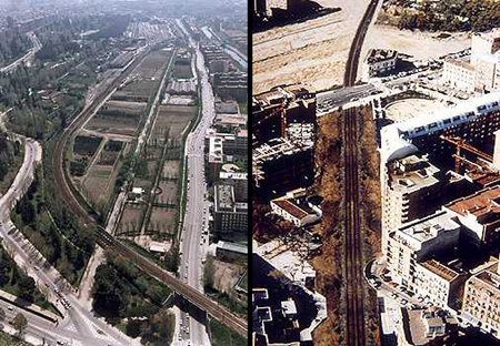
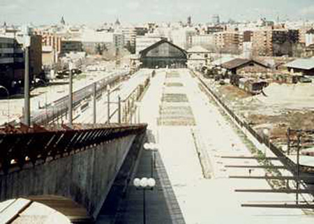
Previous state
The introduction of the railway network and its principal stations in Madrid during the 19th century, led to a clear process of transformation in the area occupied by the Pasillo Verde (green corridor) project. This southern sector of the city was established as a railway area when the peripheral line for the transportation of goods from the stations of Príncipe Pío and Delicias was built in 1866, and, later, with the building of the stations of Imperial (1881) and Peñuelas (1914). The new line brought about the specialisation of the zone, and industries and workers' housing sprang up spontaneously. They did not follow the layout of the the expansion plan designed by Castro, and created a chaotic urban sprawl which remained until the start of the Pasillo Verde project.The reorganisation of the railway network from the forties onwards, together with the decreasing use of the train as the predominant means of goods transportation, led to the industrial decline of this zone which was so close geographically to the city centre. The railway became an obstacle to urban development, a source of pollution and gradual deterioration, and an impassable barrier in the south of Madrid.
Aim of the intervention
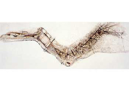
The ambitious urbanistic project was linear in design and reorganised 1.5 million m2 of urban land along the railway lines (the sector between the Puente de los Franceses to Méndez Alvaro). It set out three basic objectives: to lay double tracks, and place underground and modernise the existing rail infrastructure between the stations of Príncipe Pío and Delicias; to create a landscaped corridor with trees which would give structure to the residential zone and solve the problems of road and rail connections and services, and provide a thoroughfare for the required public recreational activities and facilities; and, lastly, to build the necessary amenities for a district such as La Arganzuela, which lacked the requisite amount of urban services.The possibility of using the old railway line as a suburban system throughout the south-west zone of the metropolitan area was considered. It would provide a link between the centre and the periphery, by establishing the Príncipe Pío-Atocha corridor for travellers, and would thus close off, in a circle, the railway network, and clearly improve journey time on local trains. At the same time, the redevelopment of spaces made available through the elimination of the railway tracks, would foster amenities, green zones and other kinds of facilities in an area where they were lacking, which would, at the same time, serve the needs of the city as a whole.
Description
The intervention carried out stretches from the Príncipe Pío station, at the Puente de los Franceses, to Delicias station, linking up the areas of the Ronda de Segovia, Paseo Imperial, Plaza de Pirámides, and also the connection with the Parque Enrique Tierno Galván.The main thoroughfare -created by placing the track in an undergound tunnel- has been urbanised between the stations of Imperial, Peñuelas and Delicias thus structuring the entire sector. This has led to the refurbishment of the existing façades and the construction of new buildings.
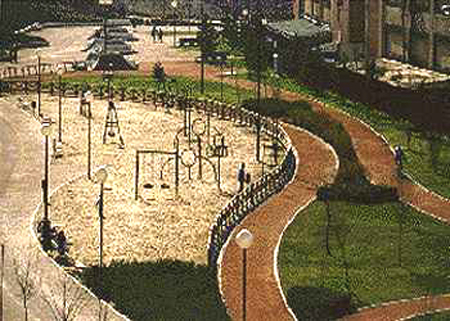
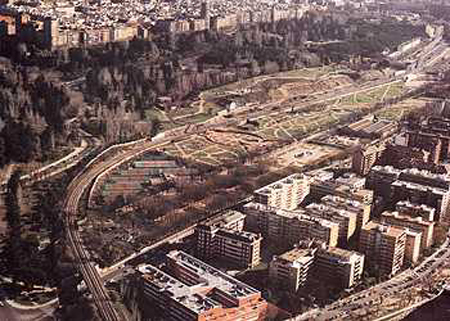
Over 50% of the surface area of the scheme has been used for green areas located in large-scale parks. Amongst these we highlight: the Parque Príncipe Pío, the most important in the area of the same name, which is geometrical in layout, and includes unusual elements such as miradors, a walkway over the tracks and a monument to Goya; Parque Peñuelas, with a children's play area and seating area, a zone on top of the residents’ car park and a sports complex; Parque de Delicias, which is linear in layout and sited on the tracks of the old Delicias station, combines its functions as a place where people can relax and walk, with that of operating rolling stock from the Railway Museum; Parque del Bronce, by the overground railway line, utilises a wedge of land between the track of Santa Catalina and the industrial buildings, and leads to the Parque de las Delicias via the Avenida del Planetario; Parque mirador de Tierno Galván, the extension of the park of the same name, is set out on a site which presents topographical difficulties and has a geometrical layout on three platforms.
The railway project basically involved redeveloping the Príncipe Pío station as a new passenger and connecting station, and building an interchange connecting with other local lines and other means of public transport.
Three new stations have been built along the railway route: Pirámides, Delicias and Méndez Alvaro, the latter of which serves as an interchange. These stations, together with the two located at the ends corresponding to
Príncipe Pío and Atocha, firmly establish the corridor for local train passengers. The entire length of the new track has been placed underground, except for the final stretch which coincides with the least built-up industrial area.
Assessment
The Pasillo Verde project has allowed the "completion" of an area of the city in a district, La Arganzuela, where building work had been interrupted by the obstacle of the old railway line: a true urban fracture in contact with the centre of Madrid. The merit of the project lay in the creation and consolidation of the city in a delapidated space by forming a residential area and a system of open spaces and other facilities, structured along a main avenue treated not as a rapid access road for vehicles, but as a series of neighbourhood streets. This thoroughfare has also incorporated a bicycle lane, 8 kilometres in length, which is the longest in Madrid. The project has also clearly improved public rail links between the city and its environs. During building work, the important historic park of the Campo del Moro was preserved and integrated into the project due to the modern system used to build the tunnel.The project was funded by its own revenue, obtained from the transfer of the plots obtained which have had profitable uses, either as housing or in the service sector, and this revenue has only been invested in this geographical area in order to finance work on infrastructure, amenities, public spaces, etc.[Last update: 02/05/2018]